2022 -2023
December 2023:
On the monitoring and modeling of volcanic emissions
Alexandros Panagiotis Poulidis 1, Simon Bittner 1, Andreas Richter 2 and Mihalis Vrekoussis 1,2,3
1 Institute of Environmental Physics (IUP-UB), University of Bremen, Bremen, Germany
2 Center of Marine Environmental Science (MARUM), University of Bremen, Germany
3 Climate and Atmosphere Research Center (CARE-C), The Cyprus Institute, Nicosia, Cyprus
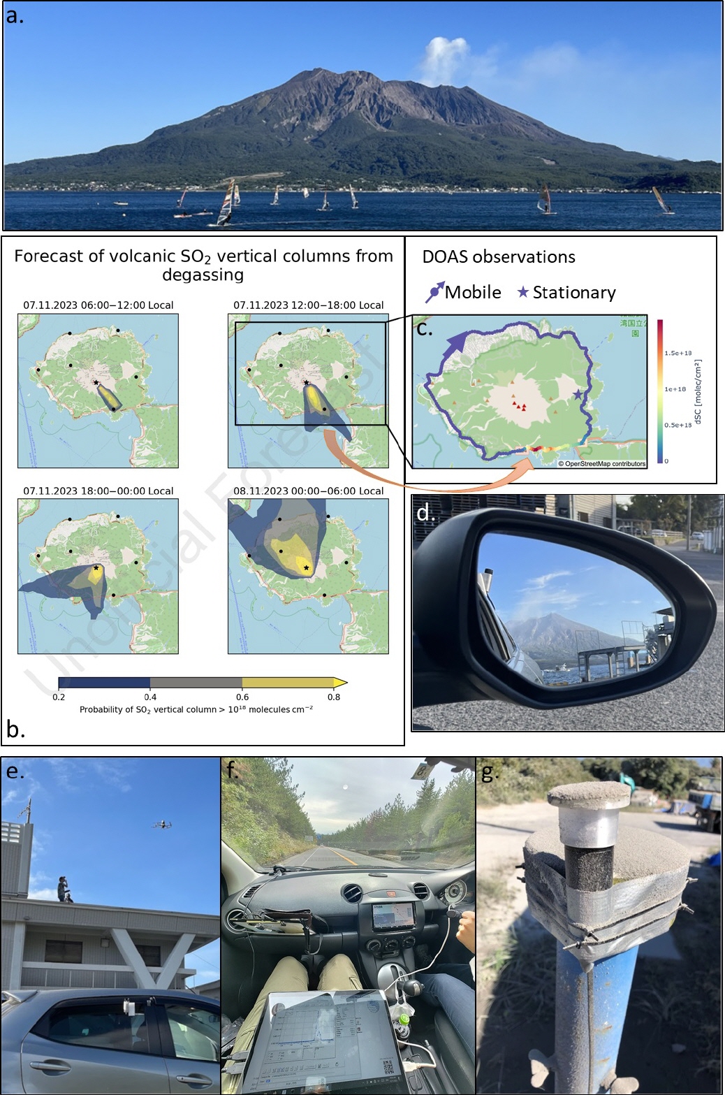
VOLCOM campaign: Due to the devastating potential of volcanoes, the scientific community tends to focus on the impacts of large-scale eruptions, leaving a gap in the study of the less spectacular, but equally important, non-explosive emissions from volcanoes. Measuring and modeling the outgassing of those emissions was the main objective of the Volcanic Emissions Observation and Modeling (VOLCOM) campaign – a pilot case study on observing near-constant "passive" volcanic emissions carried out by the LAMOS and DOAS groups at IUP between November 3-17, 2023. Our target was Sakurajima volcano in Japan, one of the most active volcanoes in the world (Fig. 1a).
For the observations, two DOAS devices were used; one for stationary and one for mobile measurements (Fig. 1d,f,g). Although the campaign focused on volcanic gas emissions, field work on an active volcano (even during periods of relative low activity) means that the probability of volcanic ash showers always needs to be considered (Fig. 1g)! The campaign had two specific objectives. First, to test the capabilities of an automated, adaptable forecasting suite designed by the LAMOS group (Fig. 1b) and second, to deploy and test in real conditions the performance of a new temperature stabilization device that allows for high-quality mobile-based-DOAS measurements (Fig. 1c,d).
During the campaign, real-time analysis of the mobile-DOAS observations (Fig. 1f), benefitted by the the negligible SO2 background, allowed us to carry out targeted measurements across and along the plume up to 50 km away from the source. Data gathered from the campaign will be used to improve our understanding of volcanic gas emissions from Sakurajima as well as their representation in chemical models.
Participants: The campaign was carried out as an international collaboration between the IUP and Kyoto University (Japan), the University of Geneva (Switzerland), the University of Clermont Auvergne (France) and the National Research Institute for Earth Science and Disaster Prevention (Japan), allowing for different synergistic measurements (e.g. Fig. 1e).
Acknowledgments:
The VOLCOM campaign was supported by grants from the Japan Society for the Promotion of Science, the University of Bremen Impulse funding scheme and the Postgraduate International Programme in Physics and Electrical Engineering (PIP), and the Integrated Program for the Next Generation Volcano Research and Human Resource Management project, funded by the Japan Ministry of Education, Culture, Sports, Science and Technology. The forecasts were performed on the HPC cluster Aether at the University of Bremen, financed by DFG within the scope of the Excellence Initiative.
November 2023:

During Polar spring, measurements often report very low ozone concentrations near the surface. These well-known ozone depletion events are the result of halogen-catalysed ozone removal. The halogens originate from seawater and are transferred to the atmosphere via the cryosphere from brine-covered ice, frost flowers or snow. While this is a natural phenomenon, it is linked to anthropogenic mercury pollution, as bromine compounds also transfer gaseous mercury into its particulate form. The latter is deposited on snow and ice and can then be transferred into the ocean ecosystem.
While the photochemistry leading to ozone depletion is rapid and local, the conditions for ozone depletion events are often influenced by large-scale meteorology. This was studied in detail in a recent publication by Zilker et al. [2023] for the Arctic station at Ny-Ålesund. When comparing the meteorological conditions in the Arctic region during days with and without low ozone observations in Ny-Ålesund, clear patterns emerged. As expected, satellite-observed tropospheric BrO columns are higher during low ozone events in the area around Ny-Ålesund and a large area up to Greenland. Similarly, lower temperatures are found around Ny-Ålesund on these days, as well as a pronounced negative anomaly in surface pressure East of Spitsbergen. The combination of the low pressure over the Barents Sea and anomalously high pressure in the region of the Icelandic Low leads to a blocking situation, bringing cold Polar air to Ny-Alesund.
With temperatures in the Arctic rising much faster than in other regions of the world, significant changes in Arctic meteorology and, thereby, Polar ozone depletion events are expected in the future, with hard-to-predict effects on the photochemistry in the Arctic boundary layer air.
Zilker, B., Richter, A., Blechschmidt, A.-M., von der Gathen, P., Bougoudis, I., Seo, S., Bösch, T., and Burrows, J. P.: Investigation of meteorological conditions and BrO during ozone depletion events in Ny-Ålesund between 2010 and 2021, Atmos. Chem. Phys., 23, 9787–9814, https://doi.org/10.5194/acp-23-9787-2023, 2023.
October 2023:
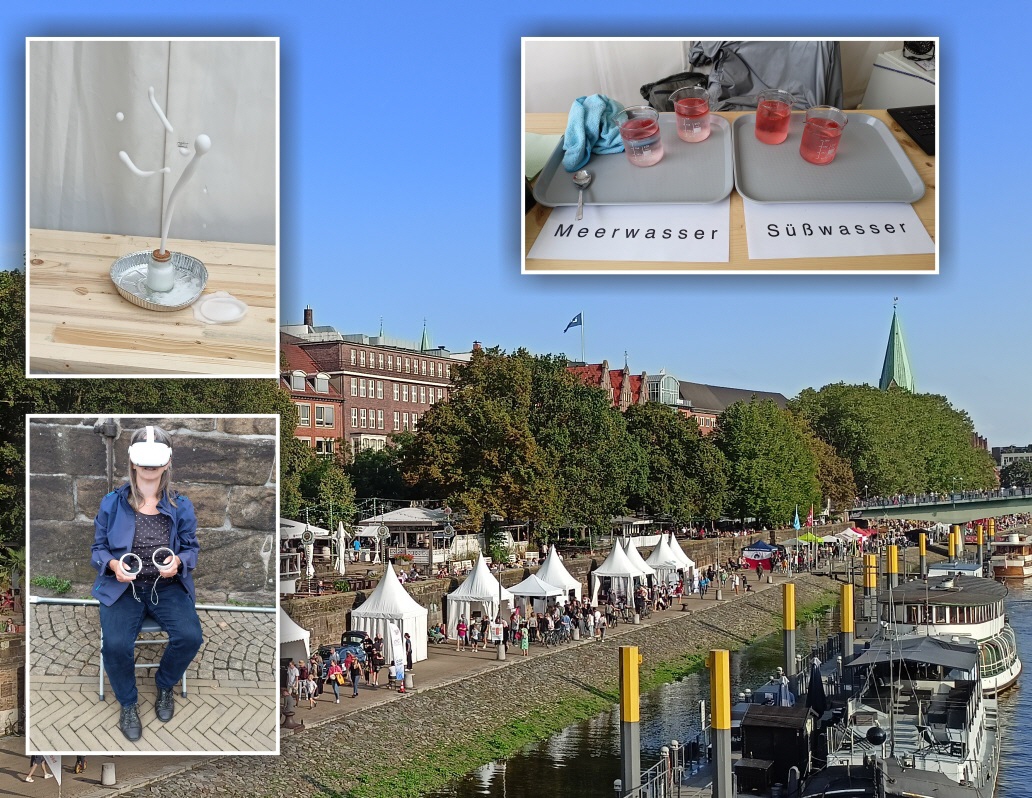
Fire and Ice: IUP at the Forschungsmeile 2023
IUP participated again at the ‘Forschungsmeile’ during the ‘Maritime Woche 2023’ in Bremen. This time, we not only answered the question: Does an ice cube melt faster in fresh water or seawater? Visitors were also informed about the impact of volcanoes on climate and could even build themselves a small erupting volcano. Furthermore, a trip into virtual reality showed pictures from a Polarsternexpedition into the arctic ocean.
Contact: Stefan Noël (stefan.noel@iup.physik.uni-bremen.de)
Field Campaigns for inland and coastal waters
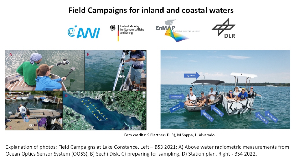
The picture shows the AWI and DLR teams during the field campaigns at Lake Constance in 2020 and, more recently, in 2022. Several measurements were made synchronously with the satellite acquisitions including above water reflectance, total suspended matters and absorption of phytoplankton and coloured dissolved organic matter. These data are used to validate Level 2 and Level 3 ocean colour products from hyperspectral and multispectral satellite sensors and to develop bio-optical algorithms to retrieve various optical water constituents (dissolved organic matter, phytoplankton groups and other particles). The image on the right shows the set of measurements taken during the EnMAP validation campaign. The German environmental satellite EnMAP was successfully launched on 1 April 2022. Over the next few years, the hyperspectral mission will take images of the Earth's surface in about 250 colours ("spectral bands"), providing more detailed information about inland and coastal waters than ever before.
For more information, see https://www.enmap.org/ and the publications of the Phytooptics group at https://www.awi.de/index.php?id=2556&L=1.
Contact:
Dr Mariana A. Soppa (msoppa@awi.de)
Prof. Dr. Astrid Bracher (abracher@awi.de)
July 2023:
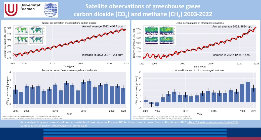
Greenhouse gases CO2 and methane continue to rise
Carbon dioxide (CO2) and methane (CH4) are important greenhouse gases and rising atmospheric concentrations lead to global warming.
The IUP at the University of Bremen is developing methods to measure [1] and interpret [2] the atmospheric distributions of these two important gases from space.
The IUP makes these data available free of charge to all interested users, either via IUP websites (see https://www.iup.uni-bremen.de/carbon_ghg/ and links there) or via third parties (e.g., ESA (https://climate.esa.int/en/projects/ghgs/) or Copernicus Climate Change Service [3] [4]).
Unfortunately, the time series for both gases currently show only one trend, namely upwards, see figure. The reason is rising emissions, whereby for methane a decrease in chemical methane decomposition in the atmosphere also makes a contribution, at least in some years. The main reason for rising CO2 concentrations is the combustion of fossil fuels (oil, coal, natural gas). For methane, natural sources such as wetlands also play an important role.
For further explanations and details on this topic and what this satellite data shows us, see the current "European State of the Climate" Assessment [5].
References:
[1] Reuter, M., Buchwitz, M., Schneising, O., Noel, S., Bovensmann, H., Burrows, J. P., Boesch, H., Di Noia, A., Anand, J., Parker, R. J., Somkuti, P., Wu, L., Hasekamp, O. P., Aben, I., Kuze, A., Suto, H., Shiomi, K., Yoshida, Y., Morino, I., Crisp, D., O'Dell, C. W., Notholt, J., Petri, C., Warneke, T., Velazco, V. A., Deutscher, N. M., Griffith, D. W. T., Kivi, R., Pollard, D. F., Hase, F., Sussmann, R., Te, Y. V., Strong, K., Roche, S., Sha, M. K., De Maziere, M., Feist, D. G., Iraci, L. T., Roehl, C. M., Retscher, C., and Schepers, D.: Ensemble-based satellite-derived carbon dioxide and methane column-averaged dry-air mole fraction data sets (2003-2018) for carbon and climate applications, Atmos. Meas. Tech., 13, 789-819, https://doi.org/10.5194/amt-13-789-2020, 2020.
[2] Buchwitz, M., Reuter, M., Schneising, O., Noel, S., Gier, B., Bovensmann, H., Burrows, J. P., Boesch, H., Anand, J., Parker, R. J., Somkuti, P., Detmers, R. G., Hasekamp, O. P., Aben, I., Butz, A., Kuze, A., Suto, H., Yoshida, Y., Crisp, D., and O'Dell, C., Computation and analysis of atmospheric carbon dioxide annual mean growth rates from satellite observations during 2003-2016, Atmos. Chem. Phys., 18, 17355-17370, https://doi.org/10.5194/acp-18-17355-2018, 2018.
[3] https://cds.climate.copernicus.eu/cdsapp#!/dataset/satellite-carbon-dioxide?tab=overview
[4] https://cds.climate.copernicus.eu/cdsapp#!/dataset/satellite-methane?tab=overview
[5] https://climate.copernicus.eu/climate-indicators/greenhouse-gas-concentrations
June 2023:
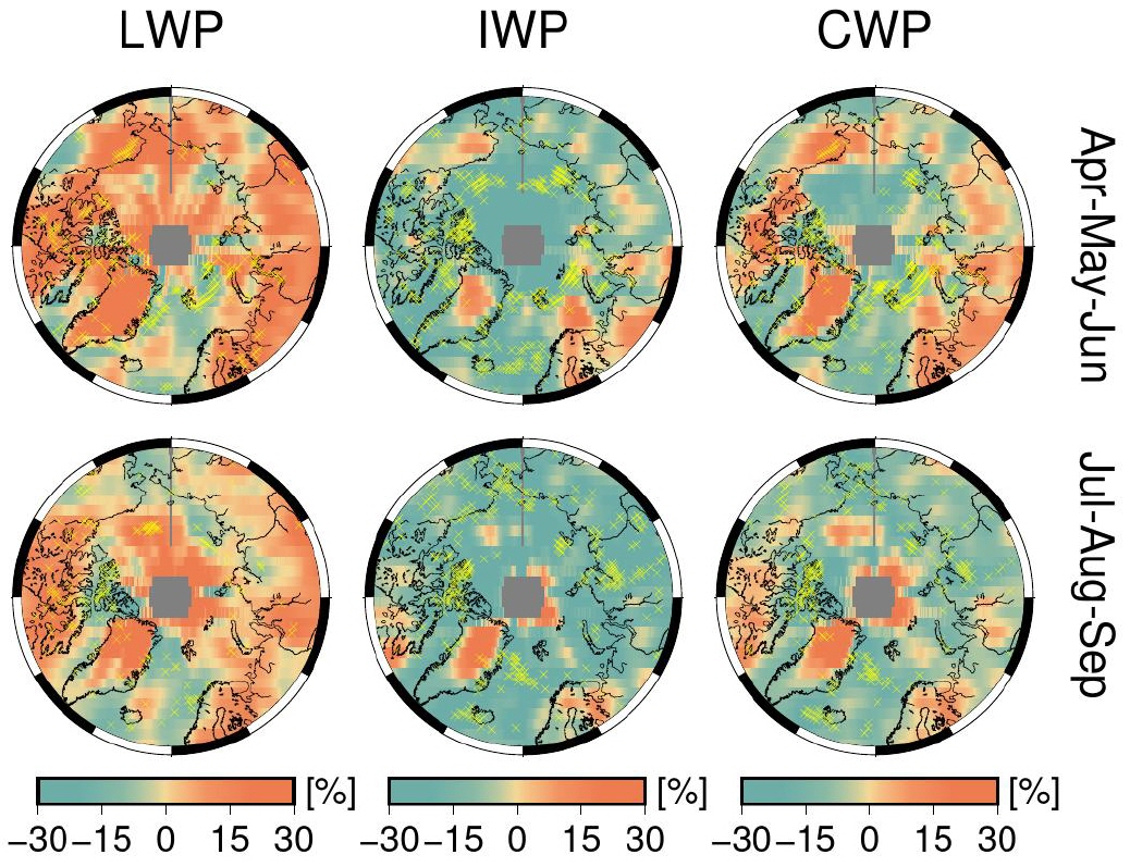
Arctic clouds are an important factor affecting the Arctic climate. They have both warming and cooling effects. The reasons for their ability to warm or cool the surface depend on several factors. These include the thermodynamic phase of the clouds (i.e., the extent to which they contain liquid or frozen water). In a recent study, the Aerosol & Clouds group at IUP/Ubremen systematically analyzed satellite data of the cloud phase.
Some cloud properties have very much changed over the past three decades. For example, the liquid water path (LWP) has increased in most regions of the Arctic. To a similar extent as the LWP has increased, the ice water pathway (IWP) has decreased. This has significant implications for the radiative budget in the Arctic.
Reference:
Lelli, L., Vountas, M., Khosravi, N., and Burrows, J. P.: Satellite remote sensing of regional and seasonal Arctic cooling showing a multi-decadal trend towards brighter and more liquid clouds, Atmos. Chem. Phys., 23, 2579–2611, https://doi.org/10.5194/acp-23-2579-2023, 2023.
Kontakt/contact: Marco Vountas vountas@iup.physik.uni-bremen.de
https://www.iup.uni-bremen.de/aerosol
April 2023:
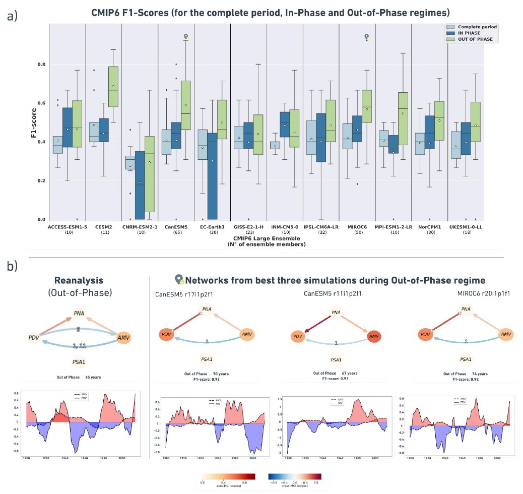
Regime-oriented causal analysis of Atlantic-Pacific teleconnections in CMIP6
Modes of natural climate variability from interannual to multidecadal timescales have large effects on regional and global climate with important socio-economic impacts (Eyring et al., 2021). Despite their importance, systematic evaluation of climate models and their simulation of internal variability remains a challenging task (Eyring et al., 2019). Here, causal discovery provides a way to estimate dynamical climate dependencies from timeseries data. In Karmouche et al. (2022), we perform a regime-oriented causal model evaluation to assess the ability of models participating in the Coupled Model Intercomparison Project Phase 6 (CMIP6, Eyring et al., 2016) to represent the observed changing interactions between the Pacific Decadal Variability (PDV) and the Atlantic Multidecadal Variability (AMV) and their extra-tropical teleconnections to the Pacific North- and Pacific South- American Patterns (PNA and PSA1). The indices for these modes of climate variability are calculated by the Climate Variability Diagnostic Package for Large Ensembles (CVDP-LE, Phillips et al., 2020).
Our figure of the month shows a comparison of causal networks for reanalysis datasets (ERSSTv5 for PDV and AMV, ERA20C_ERA5 for PNA and PSA1) and CMIP6 Large Ensemble (LE) historical simulations during the period 1900-2014. The interactions between the aforementioned modes of climate variability are hypothesized to follow different regimes depending on the physical state of the Atlantic or Pacific (i.e. AMV or PDV phase). To identify phase-dependent sets of connections (causal networks), we perform the analysis on shorter periods (regimes) that represent different phases based on the low-pass filtered AMV and PDV indices, thus identifying the regime-oriented analysis. Here, we refer to the time periods where AMV and PDV are on the same phase (both positive or both negative) by “In-Phase regime”, whereas for the periods where the two indices are on opposite phases (one negative while the other is positive) we use the term “Out-of-Phase regime”.
We run the PCMCI+ (Runge et al., 2019; Runge, 2020) causal discovery method, available as part of the Tigramite package, to estimate causal networks from CMIP6 Large Ensemble models and compare results to those from reanalysis data during different specified periods. Blue links in the resulting causal graphs translate an opposite-sign response while red links a same-sign response. The labels on the links, when shown, denote the time-delay of the response in years. The figure shows (a) a whisker plot for the distribution of F1-scores, a measure of similarity between causal networks following methods from Nowack et al. (2020), across the CMIP6 LEs during the complete period, In-Phase regime, and Out-of-Phase regime with light blue, dark blue, and green colored boxes, respectively. The white scatter points indicate that on average, CESM2, CanESM5, MIROC6, and MPI-ESM1-2-LR LEs exhibit better network similarity with observations during the Out-of-Phase regime. CanESM5 and MIROC6 LEs have the highest scores (0.92) during this regime, as indicated by the location markers on the whisker plot. In (b) we compare the causal graphs (three panels on the right) of these top-scoring realizations and their low-pass filtered AMV and PDV time series to those generated from reference reanalysis datasets (left). The networks in (b) agree on the 1-year lagged AMV→PDV link, illustrating an opposite-sign response. The positive contemporaneous PDV—PNA link is directed differently in CanESM5 r11i1p2f1 compared to reanalysis, and remains unoriented in CanESM5 r17i1p2f1 and MIROC6 r20i1p1f1. The Out-of-Phase graphs of these realizations also demonstrate an agreement on a same-sign contemporaneous AMV—PNA connection, which is weaker (lower cross-MCI value) than the PDV—PNA link. Overall, the regime-oriented causal model evaluation followed in Karmouche et al. (2022) has the potential of a powerful methodology that can be applied in a number of environment-related topics, offering tremendous insight to improve the understanding of the complex earth system and the state-of-the-art of climate modeling.
REFERENCES:
Eyring, V., Bony, S., Meehl, G. A., Senior, C. A., Stevens, B., Stouffer, R. J., and Taylor, K. E.: Overview of the Coupled Model Intercomparison Project Phase 6 (CMIP6) experimental design and organization, Geoscientific Model Development, 9, 1937–1958, 2016.
Eyring, V., Cox, P. M., Flato, G. M., Gleckler, P. J., Abramowitz, G., Caldwell, P., Collins, W. D., Gier, B. K., Hall, A. D., Hoffman, F. M., et al.: Taking climate model evaluation to the next level, Nature Climate Change, 9, 102–110, 2019
Eyring, V., Gillett, N., Achutarao, K., Barimalala, R., Barreiro Parrillo, M., Bellouin, N., Cassou, C., Durack, P., Kosaka, Y., McGregor, S., et al.: Human Influence on the Climate System: Contribution of Working Group I to the Sixth Assessment Report of the Intergovernmental Panel on Climate Change, IPCC Sixth Assessment Report, 2021
Karmouche, S., Galytska, E., Runge, J., Meehl, G. A., Phillips, A. S., Weigel, K., and Eyring, V.: Regime-oriented causal model evaluation of Atlantic-Pacific teleconnections in CMIP6, EGUsphere [preprint], https://doi.org/10.5194/egusphere-2022-1013, 2022.
Nowack, P., Runge, J., Eyring, V., and Haigh, J. D.: Causal networks for climate model evaluation and constrained projections, Nature communications, 11, 1–11, 2020.
Phillips, A. S., Deser, C., Fasullo, J., Schneider, D., and Simpson, I.: Assessing Climate Variability and Change in Model Large Ensembles: A User’s Guide to the “Climate Variability Diagnostics Package for Large Ensembles”, version 1, version, 1, 0, 2020
Runge, J.: Discovering contemporaneous and lagged causal relations in autocorrelated nonlinear time series datasets, in: Conference on Uncertainty in Artificial Intelligence, pp. 1388–1397, PMLR, 2020.
Runge, J., Nowack, P., Kretschmer, M., Flaxman, S., and Sejdinovic, D.: Detecting and quantifying causal associations in large nonlinear time series datasets, Science advances, 5, eaau4996, 2019
March 2023:
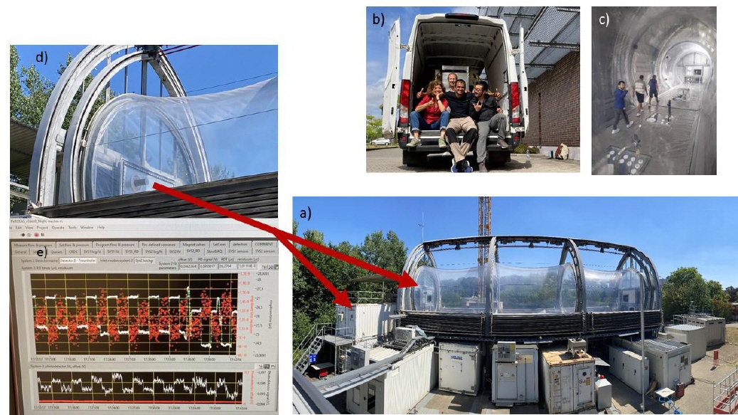
Workshop on the ROxCOMP22 campaign
Radical chemistry is of great importance for understanding the atmospheric chemical processing and formation of secondary pollutants. The TROLAS (Tropospheric Radical Observations and Laser Absorption Spectroscopy) group at the Institute of Environmental Physics has wide experience in the investigation of the distribution of peroxy radicals and their precursors, observed within airborne and ground based field measurements in different environments.
Scientists from IUP-TROLAS successfully participated with the airborne PeRCEAS
(Peroxy Radical Chemical Enhancement and Absorption Spectrometer) instrument in the 1-month long international comparison study ROxCOMP22. ROxCOMP22 aimed at improving the quality of the peroxy radical detection by bringing together instruments using different techniques to measure organic peroxy radicals worldwide. The 16 chamber experiments made in August 2022 in the SAPHIR chamber at the Forschungszentrum Jülich provided a unique opportunity to identify potential interferences or systematic errors while investigating relevant radical reactions under controlled chemical conditions.
After a calibration phase in the home laboratories, the first workshop on the discussion of the obtained ROxCOMP22 data has taken place In February 2023. The data analysis is still on-going.
Contact: Lola Andrés Hernández lola@iup.physik.uni-bremen.de
February 2023:
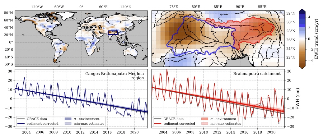
Gravity fields measured by geodetic satellites yield information on global mass variations and have proven crucial to monitor changes in water storage and fluxes. Thus, satellite gravimetry is a key component in the investigation of the massive groundwater depletion observed on the Indian subcontinent. In a current study, we look into the impact of river sediment transport on terrestrial EWH data measured by satellites of the Gravity recovery and Climate Experiment (GRACE) and its follow-on mission (GRACE-FO). While the mass loss by sediment transport in rivers is assumed to be below the detection limit of those satellites, it potentially impacts long term EWH trends derived from their data. The Indian subcontinent is drained by the Ganges and Brahmaputra rivers which constitute one of the the world's most sediment rich river systems. In this month's figure, we show the impact of sediment mass loss within the Ganges and Brahmaputra catchments on gravimetric estimates of EWH trends. Forthe whole Ganges-Brahmaputra-Meghna region, sediment transport accounts for roughly 4% of the gravity decrease currently attributed to groundwater depletion. Since most sediment is eroded from mountain regions, the impact of sediment transport on EWH trends in these regions is high (average of 14%).
Contact: Alexandra Klemme (aklemme@uni-bremen.de)
References:
Boergens, Eva; Dobslaw, Henryk; Dill, Robert (2020): COST-G GravIS RL01 Continental Water Storage Anomalies. V. 0004. GFZ Data Services. https://doi.org/10.5880/COST-G.GRAVIS_01_L3_TWS
January 2023:
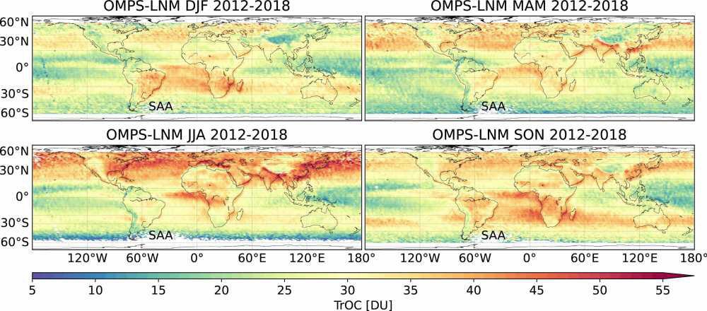
The SUOMI-NPP platform carries three instruments that measure ozone in limb and nadir viewing geometries. The OMPS-Nadir Napper (NM) provides total column ozone from the ground to the upper atmosphere. From spectral data of the OMPS-Limb profiler (LP), vertical ozone profiles are derived. Using the ozone data from both instruments, the tropospheric ozone column (from the ground to the tropopause, located between 7 and 17 km altitude, dependent on latitude) is calculated by subtracting the stratospheric column from the total. The figure shows the global seasonal mean of tropospheric ozone from 2012 to 2018 as observed by OMPS. The seasonal maps show the variable outflow of tropospheric ozone e.g. from Africa (biomass-burning regions), North-East America, and Eastern Asia (both industrial regions), where ozone is produced from chemical precursors, which are mainly air pollutants.
In addition to the OMPS tropospheric ozone algorithm, we used our advanced algorithms to retrieve the total column and profiles of ozone from both OMPS instruments. Similar algorithms have been applied to SCIAMACHY satellite data (2002-2012). In the next step, we will combine LMN tropospheric ozone data from SCIAMACHY and OMPS to obtain a long-term data record spanning at least 16 years for investigating changes in decadal timescales.
References
Arosio, C., Rozanov, A., Malinina, E., Eichmann, K.-U., von Clarmann, T., and Burrows, J. P.: Retrieval of ozone profiles from OMPS limb scattering observations, Atmos. Meas. Tech., 11, 2135–2149, https://doi.org/10.5194/amt-11-2135-2018, 2018.
Ebojie, F., von Savigny, C., Ladstätter-Weißenmayer, A., Rozanov, A., Weber, M., Eichmann, K.-U., Bötel, S., Rahpoe, N., Bovensmann, H., and Burrows, J. P., Tropospheric column amount of ozone retrieved from SCIAMACHY limb–nadir-matching observations, Atmos. Meas. Tech., 7, 2073-2096, https://doi.org/10.5194/amt-7-2073-2014, 2014.
Ebojie, F., Burrows, J. P., Gebhardt, C., von Savigny, C., Rozanov, A., Weber, M., and Bovensmann, H.: Global and zonal tropospheric ozone variations from 2003–2011 as seen by SCIAMACHY, Atmos. Chem. Phys., 16, 417-436, https://doi.org/10.5194/acp-16-417-2016, 2016.
Orfanoz-Cheuquelaf, A., Rozanov, A., Weber, M., Arosio, C., Ladstätter-Weißenmayer, A., and Burrows, J.P.: Total ozone column from Ozone Mapping and Profiler Suite Nadir Mapper (OMPS-NM) measurements using the broadband weighting function fitting approach (WFFA), Atmos. Meas. Tech., 14, 5771–5789, https://doi.org/10.5194/amt-14-5771-2021, 2021.
Orfanoz-Cheuquelaf, A, Arosio, C., Rozanov, A., Weber, M., Ladstätter-Weißenmayer, A., and Burrows, J.P., Tropospheric ozone column dataset from OMPS-LP/OMPS-NM limb-nadir matching, manuscript in preparation, 2022.
December 2022:
Johann Rasmus Nüß1, Nikos Daskalakis1, Fabian Günther Piwowarczyk1, Angelos Gkouvousis2,3, Oliver Schneising1, Michael Buchwitz1, Maria Kanakidou1,2,3, Maarten C. Krol4,5, Mihalis Vrekoussis1,6,7
1 Institute of Environmental Physics (IUP-UB), University of Bremen, Bremen, Germany
2 Environmental Chemical Processes Laboratory (ECPL), Department of Chemistry, University of Crete, Heraklion, Greece
3 Center for the Study of Air Quality and Climate Change (C-STACC), Institute of Chemical Engineering Sciences, Foundation for Research and Technology Hellas, Patras, Greece
4 Meteorology and Air Quality, Wageningen University and Research, Wageningen, the Netherlands
5 Institute for Marine and Atmospheric Research, Utrecht University, Utrecht, the Netherlands
6 Center of Marine Environmental Science (MARUM), University of Bremen, Germany
7 Climate and Atmosphere Research Center (CARE-C), The Cyprus Institute, Nicosia, Cyprus
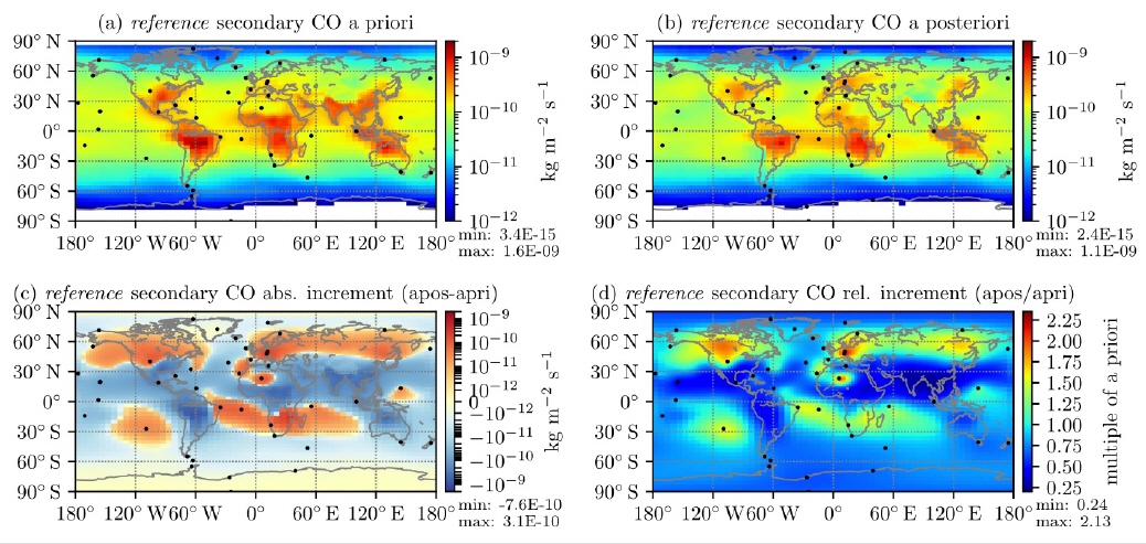
Carbon monoxide (CO) in the atmosphere adversely affects air quality and climate, making knowledge about its sources crucial. However, current global bottom-up emission estimates retain significant uncertainties. We attempt to reduce these uncertainties by optimizing emission estimates for the second half of the year 2018 on a global scale with a focus on the Northern Hemisphere through the top-down approach of inverse modeling. Specifically, we introduce observations from the TROPOspheric Monitoring Instrument (TROPOMI) into the TM5-4DVAR model. The emissions are further constrained using NOAA surface flask measurements, with their locations denoted as black dots in the figures below.
Figure (a) shows the vertically integrated bottom-up estimate for the secondary, i.e. chemical, production of CO in the atmosphere for September 2018 as taken from the full-chemistry model TM5-MP. This production field is used as part of the initial emissions, the a priori, for our inversions. The resulting optimized field, the a posteriori, is shown in Figure (b). These emission fields lead to the smallest difference between the simulated mixing ratios and those observed by both TROPOMI and the NOAA flasks. Due to its strong dependence on photochemistry, secondary CO production rates vary by multiple orders of magnitude globally, making the absolute increments between a posteriori and a priori emissions hard to interpret (panel (c)). Therefore, we show their relative difference in Figure (d), i.e. the factor by which the emissions changed at each location.
Compared to the bottom-up estimates, we observe strong broad-scale emission reductions (up to 75 %) in China and India. In part, these reductions can be attributed to policy changes in China. However, the OH climatology we use to simulate chemical loss appears to be underestimated in that region, which skews the inversion towards lower emissions as well. Conversely, we find strong local emission increments over Europe and the Sahara. These are likely artifacts caused by the model’s limited capabilities to capture the surface flask measurements at these specific stations and cannot be confirmed by satellite observations.
Notably, the mixing ratios calculated using optimized emissions from the inversion driven solely by satellite observations agree very well with the flask measurements (comparison not shown). While this holds only south of 55° N, due to model limitations, it could potentially allow for near real-time inversions purely based on satellite observations. These would then be validated against and adjusted to the surface flasks as soon as they are available.
References:
Nüß, J. R., Daskalakis, N., Piwowarczyk, F. G., Gkouvousis, A., Schneising, O., Buchwitz, M., Kanakidou, M., Krol, M. C., Vrekoussis, M: Efficacy of high-resolution satellite observations in inverse modeling of carbon monoxide emissions, submitted to Journal of Advances in Modeling Earth Systems (JAMES), 2022
Contact: Rasmus Nüß (rasmus.nuess@uni-bremen.de)
November 2022:
Methane anomalies in Greenland
Methane (CH4) represents the second most important greenhouse gas after carbon-dioxide (CO2) and is roughly 28-times more potent than CO2. It is released through human activities (agriculture, waste, fossil fuels,...) and natural processes, for example bio-chemical processes in wetlands or in thawing permafrost.
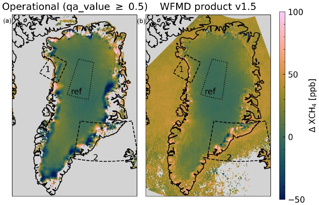
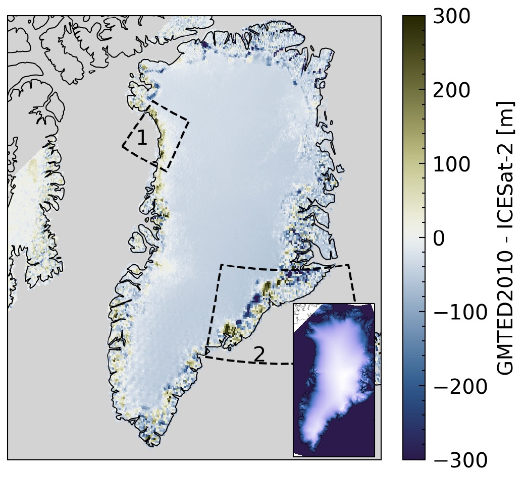
That is why we are investigating the atmospheric methane concentration (XCH4) within the framework of the junior-research group „Greenhouse gases in the Arctic“ using satellite data. Over Greenland strong methane anomalies could be observed (Fig. 1a), i.e. regions with very high or low concentrations. However these anomalies are not related to emissions from the permafrost but to inaccuracies in the digital elevation model (DEM) used in the calculations (Fig. 2), as our research has shown.
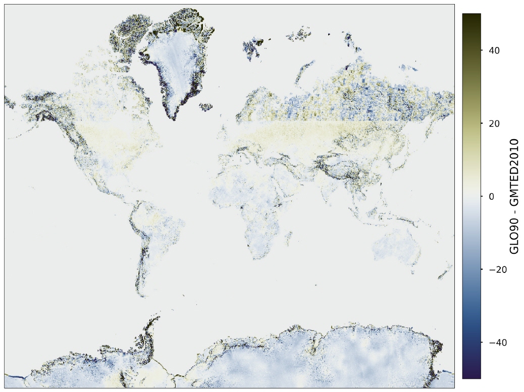
In addition to Greenland further regions show inaccuracies in older DEMs (Fig. 3). Following this finding a more recent DEM was implemented for the WFMD methane product which is developed at the IUP. The anomalies vanish in the new product both for Greenland (Fig 1b) and the other regions which improved the general quality of the product.
Reference:
Hachmeister, J., Schneising, O., Buchwitz, M., Lorente, A., Borsdorff, T., Burrows, J. P., Notholt, J., and Buschmann, M.: On the influence of underlying elevation data on Sentinel-5 Precursor TROPOMI satellite methane retrievals over Greenland, Atmos. Meas. Tech., 15, 4063–4074, https://doi.org/10.5194/amt-15-4063-2022, 2022.
Contact:
jonas_h@iup.physik.uni-bremen.de
October 2022:
Future changes in droughts in the CMIP5 ensemble analyzed with the Earth System Model Evaluation Tool (ESMValTool)
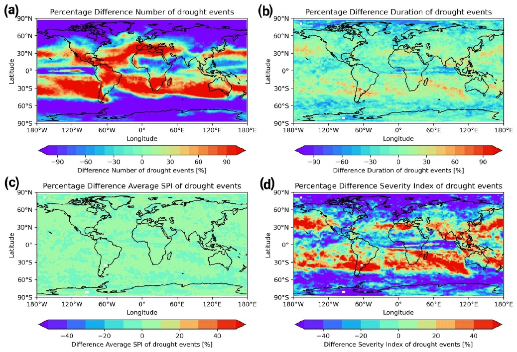
Motivated by the dry summer of this year, our image of the month shows projections of future changes in number, duration, average standard precipitation index (SPI), and severity of droughts as simulated by the climate models participating in the Coupled Model Intercomparison Project Phase 5 (CMIP5) in the RCP8.5 future scenario. The SPI describes local precipitation anomalies and can be used to identify meteorological droughts. By the end of the 21stcentury the projections show an increase of drought number, duration and severity mainly in the already dry, subtropical areas. A shift towards more frequent droughts is found for most parts of the globe for drought indices which in addition to precipitation consider the potential evapotranspiration, like the Standardized Precipitation Evapotranspiration Index (SPEI) or are based on water balance calculation, like the scaled Palmer Drought Severity Index (SC-PDSI), see e.g. Ruhe (2022).
The diagnostics to produce this figure were processed with the Earth System Model Evaluation Tool (ESMValTool), a community diagnostics and performance metrics tool designed to improve comprehensive and routine evaluation of Earth System Models (ESMs). It provides a highly optimized preprocessor written in Python (Righi et al. 2020) centralizing standard operations on input data such as regridding or computation of multi-model statistics to allow for efficient and user-friendly data processing. A large number of diagnostics is provided with the ESMValTool, covering quasi-operational and comprehensive evaluation of ESMs, like the calculation and plotting of mean state, trends, and variability for atmospheric, oceanic, and terrestrial variables (Eyring et al. 2020), as well as diagnostics for emergent constraints and analysis of future projections from ESMs in CMIP (Lauer et al. 2020). Our image of the month is the result of an ESMValTool recipe (recipe_martin18grl.yml) that has been implemented in the ESMValTool version 2.0 and publishedin Weigel et al. (2020) that summarizes diagnostics for extreme events, regional and impact evaluation.
References
Eyring, V., Bock, L., Lauer, A., Righi, M., Schlund, M., Andela, B., Arnone, E., Bellprat, O., Brötz, B., Caron, L.-P., Carvalhais, N., Cionni, I., Cortesi, N., Crezee, B., Davin, E.L., Davini, P., Debeire, K., de Mora, L., Deser, C., Docquier, D., Earnshaw, P., Ehbrecht, C., Gier, B.K., Gonzalez-Reviriego, N., Goodman, P., Hagemann, S., Hardiman, S., Hassler, B., Hunter, A., Kadow, C., Kindermann, S., Koirala, S., Koldunov, N., Lejeune, Q., Lembo, V., Lovato, T., Lucarini, V., Massonnet, F., Müller, B., Pandde, A., Pérez-Zanón, N., Phillips, A., Predoi, V., Russell, J., Sellar, A., Serva, F., Stacke, T., Swaminathan, R., Torralba, V., Vegas-Regidor, J., von Hardenberg, J., Weigel, K., & Zimmermann, K.: Earth System Model Evaluation Tool (ESMValTool) v2.0 – an extended set of large-scale diagnostics for quasi-operational and comprehensive evaluation of Earth system models in CMIP. Geoscientific Model Development, 13, 3383-3438, 2020.
Lauer, A., Eyring, V., Bellprat, O., Bock, L., Gier, B.K., Hunter, A., Lorenz, R., Pérez-Zanón, N., Righi, M., Schlund, M., Senftleben, D., Weigel, K., & Zechlau, S.: Earth System Model Evaluation Tool (ESMValTool) v2.0 – diagnostics for emergent constraints and future projections from Earth system models in CMIP. Geoscientific Model Development, 13, 4205-4228, 2020.
Righi, M., Andela, B., Eyring, V., Lauer, A., Predoi, V., Schlund, M., Vegas-Regidor, J., Bock, L., Brötz, B., de Mora, L., Diblen, F., Dreyer, L., Drost, N., Earnshaw, P., Hassler, B., Koldunov, N., Little, B., Loosveldt Tomas, S., & Zimmermann, K.: Earth System Model Evaluation Tool (ESMValTool) v2.0 – technical overview. Geosci. Model Dev., 13, 1179-1199, 2020.
Ruhe, L.: A Comparison of Drought Indices in CMIP6 Climate Projections, M.Sc. Thesis, University of Bremen, Bremen, Germany, https://www.iup.uni-bremen.de/PEP_master_thesis/thesis_2022/Ruhe_MScThesis_2022.pdf, 2022.
Weigel, K., Bock, L., Gier, B. K., Lauer, A., Righi, M., Schlund, M., Adeniyi, K., Andela, B., Arnone, E., Berg, P., Caron, L.-P., Cionni, I., Corti, S., Drost, N., Hunter, A., Lledó, L., Mohr, C. W., Paçal, A., Pérez-Zanón, N., Predoi, V., Sandstad, M., Sillmann, J., Sterl, A., Vegas-Regidor, J., von Hardenberg, J., and Eyring, V.: Earth System Model Evaluation Tool (ESMValTool) v2.0 – diagnostics for extreme events, regional and impact evaluation, and analysis of Earth system models in CMIP, Geosci. Model Dev., 14, 3159–3184, https://doi.org/10.5194/gmd-14-3159-2021, 2021.
Links
ESMValTool Website: https://www.esmvaltool.org/
Software: https://github.com/ESMValGroup/ESMValTool
Dokumentation: https://docs.esmvaltool.org/
Tutorial: https://esmvalgroup.github.io/ESMValTool_Tutorial
September 2022:
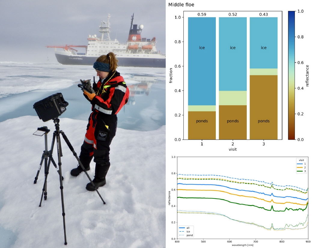
Melt ponds are puddles of surface melt water that form on the Arctic sea ice during summer. They reduce the reflectivity and albedo of the surface and thus increase the energy absorption of incoming solar radiation. This self-enhancing process is called ice-albedo feedback and plays a significant role for the amplified warming of the Arctic compared to the mid-latitudes.
The polar remote sensing group at IUP works on a retrieval that extracts surface albedo and melt pond fraction from optical satellite measurements (https://seaice.uni-bremen.de/melt-ponds/). In the past two months we were on a RV Polarstern expedition in the Arctic (https://follow-polarstern.awi.de/?lang=en) to collect important in-situ data that will help to improve the forward model in the satellite retrieval. With a hyperspectral camera, called WALL-E, detailed spectra of melt pond and ice surfaces were measured to investigate their variability and evolution. Because of the spatial extension of the measurements also an estimate of the melt pond fraction is possible. To determine the driving forces of albedo change, these measurements were repeated on the same ice floes three times between 15th and 31st July 2022 (visit 1 to 3). The ice floe got “darker” during this time period (from 0.59 to 0.43 reflectance), which is mainly due to the increase of melt pond fraction but also a reduced reflectance of the ice surface (see bar plot in upper right).
Contact:
Dr. Gunnar Spreen(gunnar.spreen@uni-bremen.de)
Hannah Niehaus (niehaus@uni-bremen.de)
Global satellite maps of N2O from GOSAT-2
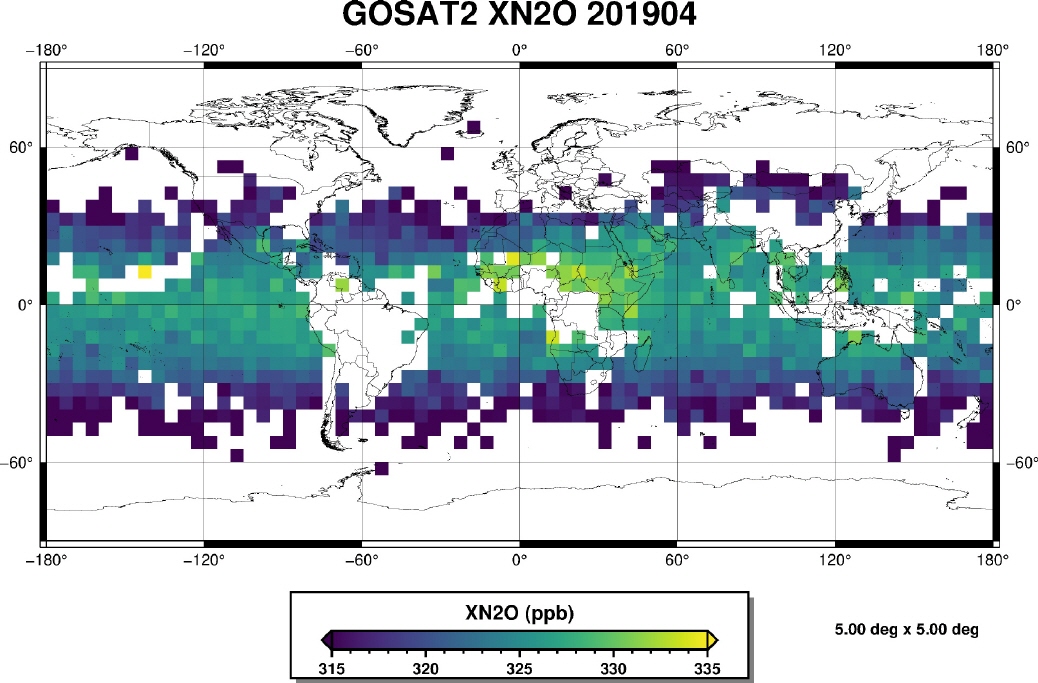
Nitrous oxide (N2O) is after carbon dioxide (CO2) and methane (CH4) the most important anthropogenic greenhouse gas. N2O is mainly produced by natural processes (e.g. by bacteria), but is also released in agriculture (fertilisers) and biomass burning processes. Although the atmospheric concentration of N2O is about 1000 times smaller than for CO2, the global warming potential of N2O is almost 300 times larger, which makes it a relevant contributor to climate change.
However, global measurements of N2O especially from satellites are sparse. The map in the image (from Noël et. al, 2022) shows the atmospheric distribution of XN2O (i.e. the total dry column average N2O) in April 2019 derived at IUP from measurements of the Japanese GOSAT-2 satellite.
As can be seen, total column concentrations of N2O are larger in the tropics than at higher latitudes. This is because most of the N2O is produced and located in the lower atmosphere, the troposphere, which reaches higher in the tropics.
Reference:
Noël et al., Retrieval of greenhouse gases from GOSAT and GOSAT-2 using the FOCAL algorithm, Atmos. Meas. Tech., 15(11), 3401–3437, 2022, doi: rm10.5194/amt-15-3401-2022.
https://amt.copernicus.org/articles/15/3401/2022/
Contact:
Stefan Noël (stefan.noel@iup.physik.uni-bremen.de)
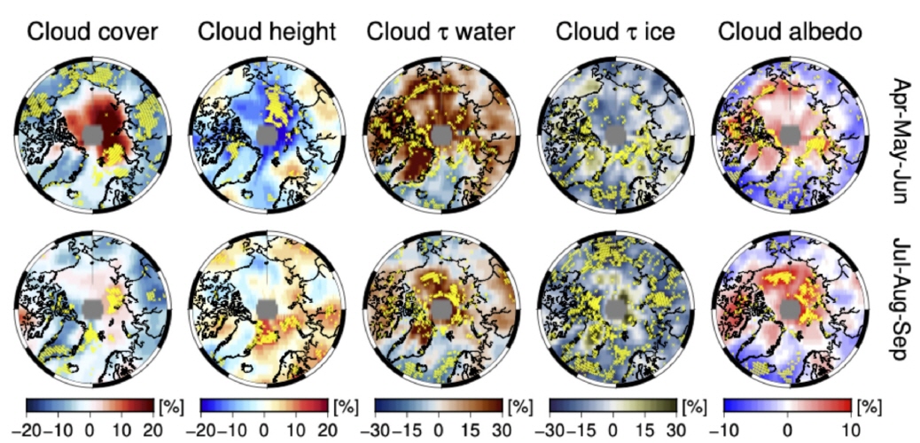
A recent study conducted by the IUP "Cloud Aerosol Surface PArameter Retrieval" group as part of the Transregio (AC)³ investigates clouds, their properties, and the magnitude of the radiative effect of clouds in the Arctic based on satellite data.
Arctic clouds are an important factor in influencing Arctic climate. They have both warming and cooling effects. The reasons whether they warm or cool depend on different conditions. These include the microphysical properties of the clouds, the illumination, the thermodynamic phase of the clouds (i.e., to what degree they contain liquid or frozen water), and the reflectivity of the ground.
Although when viewed over the entire Arctic the cloudiness has not changed appreciably over time, some cloud properties have. For example, the optical thickness of liquid water clouds and that of pure ice clouds. Partially significant changes in cloud brightness (cloud albedo) are also obvious.
Reference: The aerosol, cloud and surface property group "Pan-Arctic and regional trends of reflectance, clouds and fluxes: implications for Arctic Amplification" (2022)
Kontakt/contact: Marco Vountas vountas@iup.physik.uni-bremen.de
or Luca Lelli luca@iup.physik.uni-bremen.de
https://www.iup.uni-bremen.de/aerosol
June 2022:
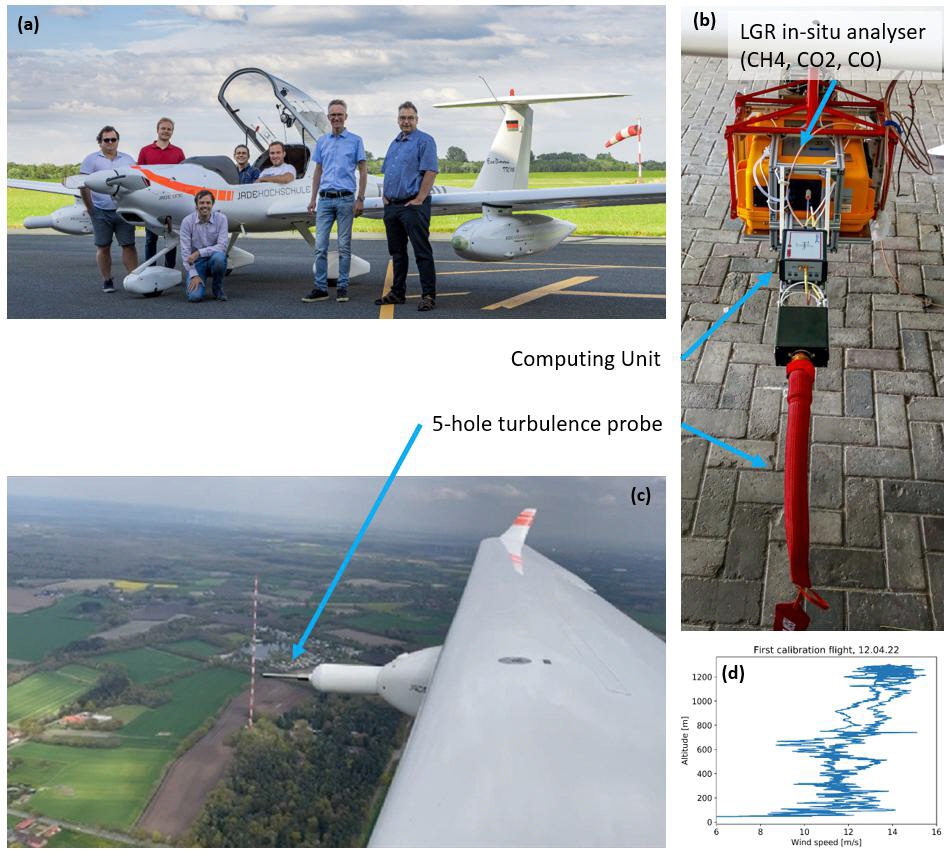
New measurement suite to improve Greenhouse Gases observations from aircraft,
University Bremen, Institute of Environmental Physics
Scientists at the Institute of Environmental Physics are specialised in the development and deployment of various types of airborne sensors to locate and quantify emissions of anthropogenic greenhouse gases by measuring atmospheric Methane (CH4) and Carbon dioxide (CO2) distributions. To accurately estimate emissions from those distributions, precise knowledge of the local wind field is necessary. Therefore, in spring 2022, a newly acquired 5-hole turbulence probe together with a in-situ greenhouse gas analyser, were successfully mounted in one of the wing pods of the motor glider of Jade Hochschule Wilhelmshaven. The Diamond HK36TTC-ECO is a flexible platform for different remote sensing tasks, as it needs no certification process to install sensors. First test flights in cooperation with Jade Hochschule Wilhelmshaven were successfully conducted in northern Germany to calibrate the new instrument. Additionally, fly-bys at the ICOS measurement tower in Steinkimmen/Ganderkesee operated by the German Weather Service DWD, which observes the vertical wind profile at 5 different altitudes till an altitude of 250m, were carried out. Those measurements are used for comparisons and will improve the calibration quality of the wind probe further. Additional, calibration flights comparing measurements from airborne, LIDAR, drone, and tower measurements are planned.
Contact: heinrich.bovensmann@uni-bremen.de
May 2022:
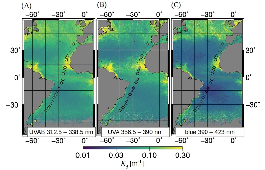
TROPOMI-retrieved underwater light attenuation in three spectral regions in the ultraviolet to blue. Frontiers in Marine Science 9: 787992. doi:10.3389/fmars.2022.787992
Sunlight plays an important role for biological, chemical, and physical processes in the ocean. High-energetic ultraviolet (UV) radiation can have damaging and beneficial effects for aquatic organisms and its interaction with the ocean is generally complex. Most processes feedback with climate warming. Satellite-based observations of light penetration into the ocean in combination with modeling are used to understand these processes and make predictions for the future ocean and climate scenarios in general. Traditional satellite ocean color sensors don’t measure the ultraviolet range. Information on UV light penetration is only inferred indirectly from measurements in the visible wavelength range, naturally connected to lager uncertainties.
This study exploited backscattered UV to blue light data at continuous spectral resolution of 0.5 nm of the TROPOMI sensor onboard the Sentinel-5-Precursor satellite. We present the first direct satellite-based observations of shortwave penetration, in terms of the diffuse attenuation (Kd) into the ocean ranging from the ultraviolet to the blue spectral domain. Our approach is based on Differential Optical Absorption Spectroscopy to retrieve the vibrational Raman scattering (VRS) signal and then combined with coupled ocean-atmosphere radiative transfer modeling (RTM) to derive Kd in the UV range (312.5-338.5 nm and 356.5-390 nm), additionally to the blue Kd (390-423 nm). The VRS signal is well detected in TROPOMI measurements (fit errors <15%) and TROPOMI Kd retrievals exhibit low sensitivity to parametrization of oceanic and atmospheric effects and show good agreement to in situ Kd obtained from in situ measured underwater light spectra.
These products have high potential satisfying user needs in the modeling community which require spectral information on shortwave light penetration for improving estimates of the ocean’s heat budget, primary productivity, photochemical reaction rates of climatically important compounds, and the UV dose rates as an indicator for damaging effects on aquatic organisms.
April 2022:
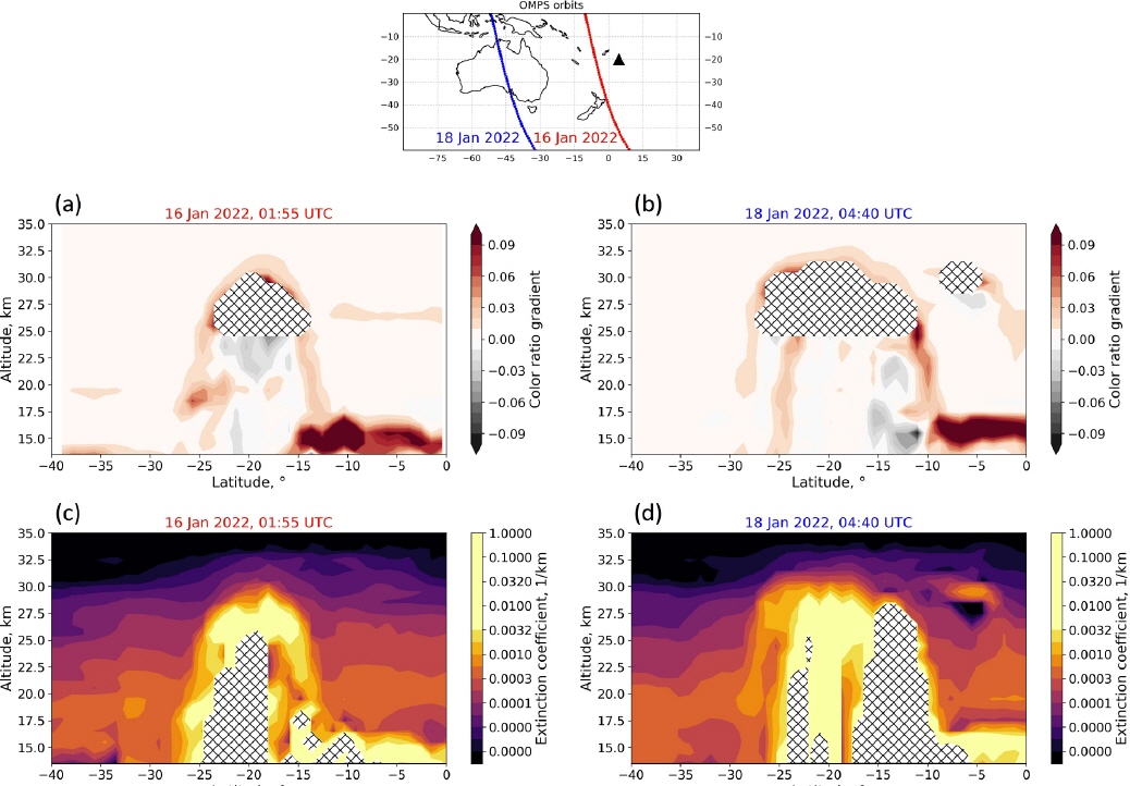
Hunga Tonga-Hunga Ha'apai eruption
On 15th of January 2022, the undervolcano Hunga Tonga-Hunga Ha'apai (20.55°S, 175.40°W), ejected material consisting of gas, steam, and ash up to an altitude of 58 km. This plume height is exceptional and the highest known since satellite observations. Even the second largest volcanic eruption of Mount Pinatubo in the Philippines in 1991 „only“ reached a height of 35 km. Probably, the combination of volcanic heat and superheated moisture from the ocean pushes the aerosols in such unprecedented altitudes.
The uppermost part of the plume sublimated quickly due to the extreme dryness in the mesosphere. In around 30 km altitude, the volcanic plume formed an extensive umbrella carried westward by the strong stratospheric winds. As can be seen from the Figure, this umbrella rose and expanded due to thermal buoyancy and dispersion. It circled the globe within two weeks. The volcanic aerosols will remain in the stratosphere for a long time but have no significant impact on the global climate. The injected aerosol content of 0.4 teragram of sulphur dioxide was too low for that. For comparison: Mount Pinatubo emitted about 18.5 teragram of sulphur dioxide into the stratosphere, temporarily lowering the global temperature by about 0.6°C.
References:
Malinina, E., Rozanov, A., Niemeier, U., Wallis, S., Arosio, C., Wrana, F., Timmreck, C., von Savigny, C., and Burrows, J. P.: Changes in stratospheric aerosol extinction coefficient after the 2018 Ambae eruption as seen by OMPS-LP and MAECHAM5-HAM, Atmos. Chem. Phys., 21, 14871–14891, https://doi.org/10.5194/acp-21-14871-2021, 2021.
https://earthobservatory.nasa.gov
March 2022:
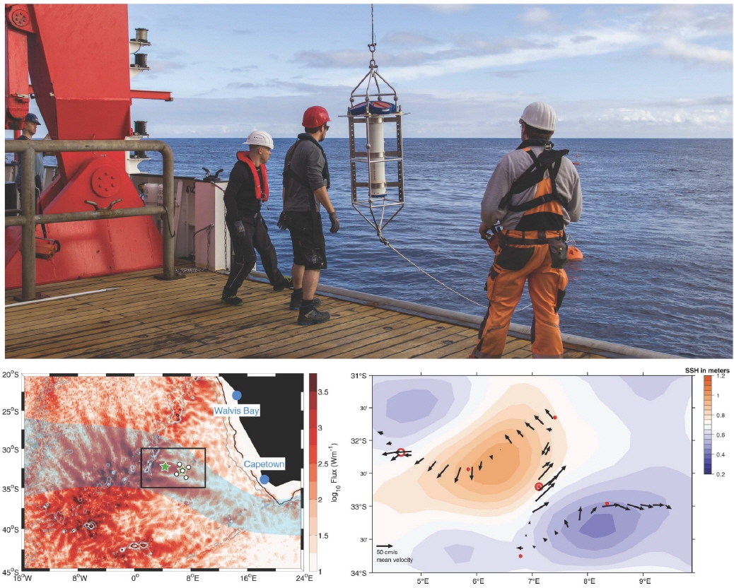
Expedition number 283 of the German research vessel SONNE, which was carried out in spring 2021, was rather special. Due to the Corona pandemic, many research cruises had been cancelled, and now several oceanographic moorings in the South Atlantic had to be recovered and new instruments deployed. Scientists and students from four institutes embarked on the long voyage, which startedin Emden for infection control reasons and ended there after 64 days at sea and more than 17,000 nautical miles. Our group from IUP deployed two tall moorings with current meters and thermistors as well as 5 bottom-mounted inverted echo sounders, which is part of the observational program of the Collaborative Research Center TRR 181 “Energy Transfers in Atmosphere and Ocean” (www.trr-energytransfers.de).
The objective of the experiment is to get many-months-long time series of current velocities and temperature to study the interaction of internal gravity waves emanating from the Walvis Ridge and Agulhas Eddies that travel from south of Africa into the South Atlantic. These interactions between waves and eddies and their exchange of kinetic energy are not yet fully understood. Tidal currents at seamounts and continental shelves, for example, exciteinternal gravity waves that can travel hundreds of kilometers across ocean basins before eventually contributing to turbulent mixing in the water column. Their loss of energy is determined by a number of processes and interactions. In our project, we study the scattering and refraction of tidal waves in the interior of the oceans with the goal of better integrating these processes intoclimate models.
February 2022:
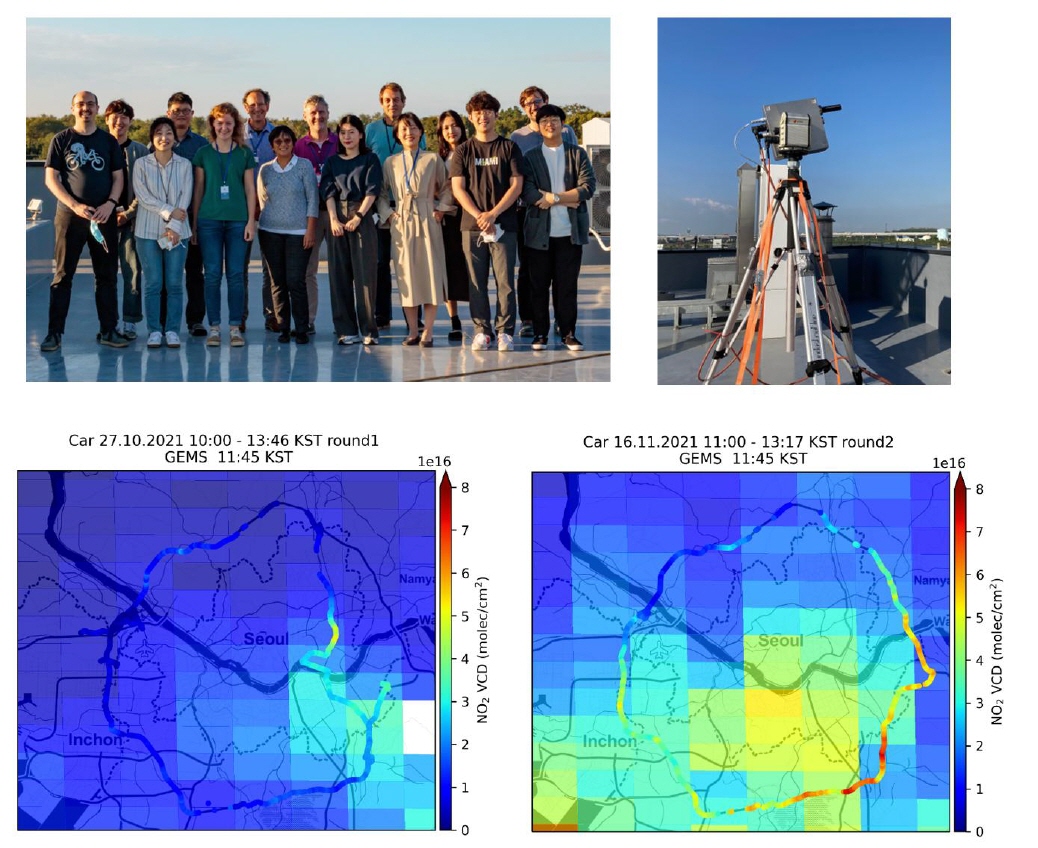
The GMAP-2021 campaign
In October and November 2021, IUP Bremen participated in the GMAP-2021 (GEMS Map of Air Pollution) campaign in South Korea. This campaign brought together instruments from South Korea, the US, Belgium, the Netherlands, and Germany to collect data on air pollution in South Korea for the validation of the GEMS (Geostationary Environment Monitoring Spectrometer) satellite instrument. GEMS is the first geostationary satellite instrument dedicated to air quality, launched by the South Korean space agency in February 2020 and providing measurements of key pollutants over Asia in hourly resolution. Similar instruments will be launched by the US (TEMPO) and Europe (Sentinel-4) in the coming years.
During the GMAP campaign, IUP Bremen installed a multi-azimuth MAX-DOAS instrument on the rooftop of the NIER (National Institute of Environmental Research) building at Incheon. This instrument provides data on the abundance of NO2, HCHO, SO2and other pollutants valuable for long-term validation of GEMS retrievals. It will continue to operate at the location for the coming months. Similar instruments have been deployed by other groups in the Seoul Metropolitan Area and other parts of South Korea, and are expected to help in characterizing and improving the satellite data products.
In addition to the stationary measurements, a large number of mobile DOAS measurements was performed from cars to investigate the spatial variability of NO2, to monitor temporal changes and to estimate NOx emissions from Seoul. The observations show a large variability of NO2within individual GEMS satellite pixels, rapid changes over time and the impact of both, local emissions and transport to the observed NO2column amounts. These data are complemented by both in-situ and remote sensing observations from several aircraft overpasses over the same area.
Further reading:
Jhoon Kim et al., New Era of Air Quality Monitoring from Space: Geostationary Environment Monitoring Spectrometer (GEMS), BAMS, 2020, DOI: https://doi.org/10.1175/BAMS-D-18-0013.1
January 2022:
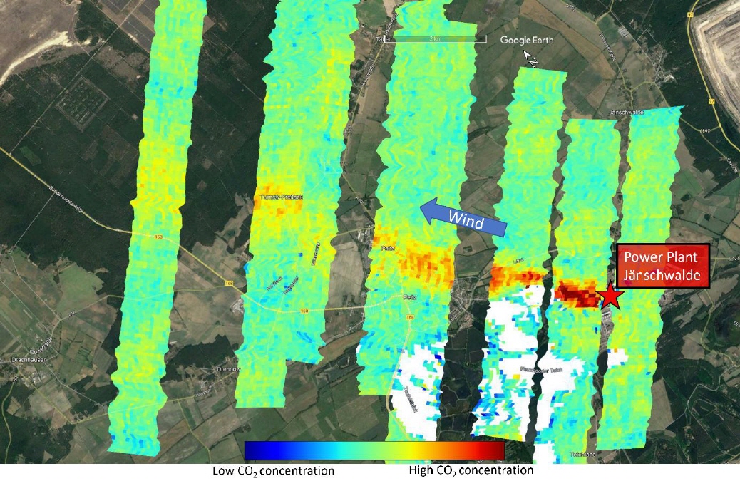
Scientists of the Institute of Environmental Physics are developing new optical sensors to image atmospheric Methane (CH4) and CO2 distributions from aircraft in a similar way as future satellites, but with higher sensitivity to point source emissions. The prototype of the push broom imaging spectrometer – called MAMAP2D-Light – was successfully mounted in the wing pods of the motor glider of Jade Hochschule Wilhelmshaven (see IUP picture of the month June 2021) and successfully performed its first flight over the power plant Jänschwalde near Cottbus, Germany.
Subsequent data analysis resulted in the image shown above, where the CO2 plume of the power plant Jänschwalde is clearly visible in reddish colors. The emissions estimated from this data set matches within its uncertainty range the average emissions during the week of the overflight, and the results and additional performance characteristics have been presented at the fall meeting of the American Geophysical Union in December 2021 (1). In summer 2022 this instrument will be flown onboard the German high altitude research aircraft HALO as part of the international COMET 2.0 campaign targeting high latitude emissions of CH4 and CO2 from wetlands as well as geological seeps and oil/gas production in Canada.
Contact: heinrich.bovensmann@uni-bremen.de
(1) Jakob Borchardt, Konstantin Gerilowski, Sven Krautwurst, Wilke Thomssen, Jan Franke, Martin Kumm, Pascal Janßen, Jens Wellhausen, Heinrich Bovensmann, John P. Burrows(2021), The New Imaging Spectrometer MAMAP2D-Light– Initial Calibration and First Measurement Results, [A25G-1759] presented at 2021 Fall Meeting, AGU, 13-17 Dec., https://agu2021fallmeeting-agu.ipostersessions.com/default.aspx?s=65-03-4F-E7-23-6B-ED-73-35-C6-6C-C5-C7-C1-9E-A9


